Where can you see satellite images of our planet? Paris, New York, Niagara Falls, Everest and many other known and unknown places on Earth, we can see with the help of an interactive virtual globe - the program Google Planet Land.
With the help of this program you will see our entire planet on the screen of your monitor. Free program Google Earth includes a globe, atlas, and travel guide service.
Using this program, you can move to the desired location anywhere in the world. In the Google Earth program, you can see the relief of our planet, city streets, 3D buildings, 3D trees, historical images, the ocean, the sky, the Moon and Mars.
Google Earth can also be used for educational purposes. This is one of those programs that is always installed on my computer.
To install the program on your computer from the official Google website, go to the site www.google.com. On the download page, you will need to click on the "Accept the terms and download" button. You can uncheck the boxes next to the corresponding items if you do not want to download the Google Chrome browser on your computer at the same time.
The download page will download the installer for the Google Earth program. Then, after launching the installer, the installation of the Google Earth program on the computer begins.
After the Google Earth program has been installed on your computer, launch the program from the shortcut on the "Desktop" or from the "Start" menu => "All Programs" => "Google Earth" => "Google Earth".
Google Earth Settings
After opening the Google Earth program window, the "Sidebar" will be opened on the left side of the program window. In order for our planet to be displayed in the entire program window, the “Sidebar” can be removed.
To do this, go to the "View" menu, and then uncheck the box next to the "Sidebar" item, or by clicking on the appropriate button below the program menu bar.
In the right corner of the program window there are control buttons for the Google Earth program.
With the top button, you can change the viewing angle so that you can observe the displayed surface not only from above. With this button you can rotate the globe or move the orientation to the cardinal points. If you click on the letter "N", then the globe will be oriented to the north. These commands can be executed with the mouse by pressing the left button and moving the mouse.
With another button below, you can move around the space by clicking on the corresponding side. If the mouse cursor is brought closer to the edge of this button, then the movement speed will be faster than when the cursor is closer to the center of the button.
By moving the slider along the axis, you can zoom in or out on the image loaded by the program. You can also zoom in or out on Earth images by moving the mouse wheel forward or backward.
At the bottom of the program window are displayed: "date of shooting", "coordinates of the place" from which the view of our planet is displayed, "height above sea level" and "height of the terrain view".

The program is already configured by default, but you can still make some more settings. To do this, in the "Tools" menu, click on the "Settings" item. Here you can make your settings in the appropriate tabs, and I will focus on the settings in the "3D View" tab.
You can choose, if the power of your computer allows you, higher settings for a better display satellite images. If you use higher settings, images will take longer to load, it also depends on the speed of your internet connection. The higher the speed of the Internet connection, the faster images of the Earth will be downloaded to your computer.

In the graphics mode "DirectX" there will be a better display of images loaded by the program. You can experiment with the quality of the relief display. I am using the program settings shown in this image on my computer.

If you want the images not to be distorted when you zoom in, then go to the menu “Tools” => “Settings” => “Navigation”.
In the "Navigation" tab, uncheck the checkbox opposite the item "Tilt automatically and enter view from the ground", and then check the box next to the item "Do not tilt when viewing automatically". You can check the box "Gradually slow down the rotation of the Earth when turning or approaching." After that, click on the “OK” button.
In this article, I only talk about the main features of the program. You yourself can enter the menu items of the program and make the appropriate settings for your needs.
You can simply move around the satellite map of the Earth in manual mode, using the program's control buttons, or simply with the mouse.
To look at satellite images, you will have to wait a bit until the image is downloaded completely from the Internet. An image taken from a higher altitude loads faster.
To move to a specific geographical point, in the "Search" field you need to enter the name of the settlement. When you enter a name in the "Search" field, hints appear. You can add to the name of the city and the street with the house number.
This, however, applies to large settlements. If the settlement is small and it is located in the countryside, it is better to enter the name of a nearby city in order to get to the place of interest from it. Not all small settlements can be marked with text on the pictures in the program.
The detail of satellite maps depends on the population of a particular area. More densely populated areas of the Earth have more detailed images than sparsely populated areas. Deserts, jungles and polar regions do not have very high detail in the pictures.
Images of the Earth are gradually updated, in the lower right corner of the program window there is a date of shooting a particular place.
Traveling in Google Earth
In order to move to a specific place, you need to enter the name of this place in the "Search" field. Enter in the "Search" field the expression: "Niagara Falls", and then double-click on the "Start Search" icon located next to it. The program will take you to the selected location.
In the image that opens, you will see what Niagara Falls looks like from a height of 3.01 km.

You can get close to the waterfall and view it from all sides. In the image you see a view of the waterfall from a height of 604 meters. This image shows a lot of markings of the places where the photos were taken.
Other objects are also marked on satellite images. These can be hotels, various institutions, attractions, large stores, historical monuments and much more. When you right-click on such an object, reference Information about this particular object.

When you click on the photo mark, you will see a photo taken from the marked place on the image. You can also add your photos by uploading them to the Panoramio photo hosting with the coordinates of the shooting location.

You can see Niagara Falls from the other side too by moving to a new location.

You can hide the display of the marks of the taken photos on the uploaded image. To do this, go to the "Sidebar" by clicking on the appropriate button. In the "Sidebar", in the "Layers" section, you will need to uncheck the box next to the "Photos" item. After that, the image will not have these marks.
If you want to remove all extra information, then you need to uncheck the checkbox opposite the item "Main database" in the "Layers" section, and then close the "Sidebar".
In the "Layers" section, you can add or remove various effects, such as displaying 3D buildings. Such displays of 3D buildings are mainly for large cities, and mainly located in the USA and Western Europe.

In the image, near the famous Eiffel Tower, you see not only cars, but even individuals standing near the tower. With the help of the program, you can also view historical photographs taken in this place.

Flight Simulator at Google Earth
In the Google Earth program, you can simulate a flight on a virtual simulator by selecting the type of aircraft for this. To do this, you need to enter the "Tools" menu, and then click on the "Enter flight simulator" item.
In the Flight Simulator window, you can select the type of aircraft and the starting position for starting the flight. After that, you need to click on the "Start Flight" button.
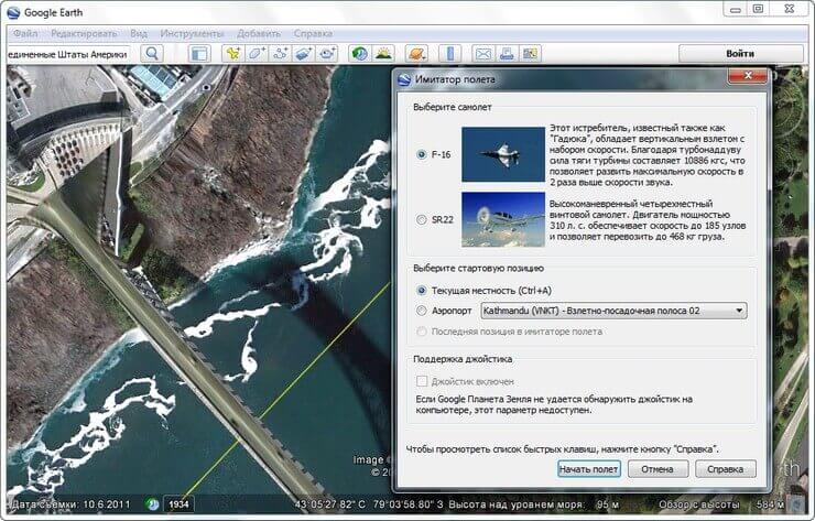
After that, you can fly above the ground in a virtual plane.

Viewing the surface of the Moon and Mars
Using the Google Earth program, you can see the surface of the Moon and Mars. To do this, click on the button with the image of the planet and select the appropriate item. To depict the surface of the Moon and Mars, space photographs taken by the US agency NASA are used.
You can change the height of the sun and therefore change the angle of the shadow. This image shows the surface of Mars.

If you select the "Sky" item, then with the help of the program it will be possible to view the night sky and objects of the Universe on the starry sky map. Complementing the image are photographs taken with the Hubble Space Telescope. Clicking on an object displays additional help information.
In some places, you can go underwater and see the topography of the seabed if you check the appropriate boxes in the "Layers" section.
The program allows you to make tours of attractions. In the Google Earth program, you can create your own trips and save them for later viewing. To do this, check the appropriate items in the "Layers" section.
In the "File" menu, after clicking on the item "View at Google Maps» you can see the plot of land you have chosen using the service of the same name. To go back to the Google Earth program, you need to click on the "Back to Google Earth" button in the upper left corner.
Satellite photos can be saved to your computer. To do this, after you have chosen a save location, simultaneously press the "Ctrl" + "Alt" + "S" buttons on the keyboard.
In the Explorer window that opens, select a location to save the image and give the image a name. After that, click on the "Save" button.
The free Google Earth program can be used not only for entertainment, but for practical purposes. For example, you are planning a vacation, or going on a business trip. Previously, you can look at the place of interest to you using the Google Earth program.
After that, you will already have a certain idea about this place, and you can choose a place to rest more consciously.
Article Conclusions
With the Google Earth program, you can look at any place on the globe using satellite photos, and also find in the program the house you live in or the place where you will go on vacation.
The other day, NASA announced that on July 19, the Cassini probe orbiting Saturn will photograph the Earth, which at the time of shooting will be at a distance of 1.44 billion kilometers from the apparatus. This is not the first photo shoot of this kind, but the first one that was announced in advance. NASA experts hope that the new image will take pride of place among such famous pictures of the Earth. Like it or not, time will tell, but for now we can remember the history of photographing our planet from the depths of space.
Since ancient times, people have always wanted to look at our planet from above. The advent of aviation gave mankind the opportunity to rise beyond the clouds, and soon the rapid development of rocket technology made it possible to obtain photographs from truly cosmic heights. The first pictures from space (according to the FAI standards, according to which space begins at a height of 100 km above sea level) were made in 1946 using a captured FAU-2 rocket.
The first attempt to photograph the earth's surface from a satellite was made in 1959. Satellite Explorer-6 I took this amazing photo.

By the way, after the mission of Explorer-6 was completed, he still served the American Motherland, becoming a target for testing anti-satellite missiles.
Since then, satellite photography has developed at an incredible pace and now you can find a bunch of images of any part of the earth's surface for every taste. But the vast majority of these photos were taken from low earth orbit. What does the Earth look like from more distant distances?
Snapshot of the Apollos
The only people who could see the entire Earth (roughly speaking in one frame) were 24 people from the Apollo crews. We have a few classic shots as a legacy from this program.

And here is a picture taken with Apollo 11, where the earth terminator is clearly visible (and yes, we are not talking about a famous action movie, but about a line dividing the illuminated and unlit parts of the planet).
Photo of the Earth's crescent over the surface of the Moon, taken by the crew Apollo 15.

Another Earthrise, this time over the so-called dark side of the Moon. Photo taken with Apollo 16.
"The Blue Marble"- another iconic photograph taken on December 7, 1972 by the crew of Apollo 17 from a distance of approximately 29 thousand km. from our planet. It wasn't the first image to show a completely illuminated Earth, but it became one of the most famous. The Apollo 17 astronauts are so far the last people who could observe the Earth from this angle. For the 40th anniversary of the photo, NASA remake this photo by gluing a bunch of frames from different satellites into a single composite image. There is also a Russian analogue made from the Elektro-M satellite.


When viewed from the surface of the Moon, the Earth is constantly at the same point in the sky. Since the Apollos landed in the equatorial regions, in order to make a patriotic avatar, the astronauts had to get the hang of it.
Shots from moderate distances
In addition to the Apollos, a number of AMS photographed the Earth from a great distance. Here are the most famous of these pictures

Very famous photo Voyager 1 taken on September 18, 1977 from a distance of 11.66 million kilometers from Earth. As far as I know, this was the first image of the Earth and the Moon in one frame.

A similar picture taken by the device Galileo from a distance of 6.2 million kilometers in 1992

Photo taken on July 3, 2003 from the station Mars Express. The distance to Earth is 8 million kilometers.

And here is the most recent, but oddly the worst quality picture taken by the mission Juno from a distance of 9.66 million kilometers. So think - either NASA really saved on cameras, or because of the financial crisis, all the employees responsible for photoshop were fired.
Pictures from Martian orbit


This is what the Earth and Jupiter looked like from the orbit of Mars. The pictures were taken on May 8, 2003 by the apparatus Mars Global Surveyor, which was at that time at a distance of 139 million kilometers from the Earth. It is worth noting that the camera on board the device could not take color images and these are pictures in artificial colors.

Map of the location of Mars and planets at the time of shooting

And this is how the Earth looks already from the surface of the red planet. It is difficult to disagree with this inscription.

And here is another image of the Martian sky. The brighter point is Venus, the less bright one (pointed to by the arrows) is our home planet
Who cares, a very atmospheric photo of a sunset on Mars. It is somewhat reminiscent of a similar frame from a movie Stranger.
Pictures from the orbit of Saturn

in higher resolution
And here is the Earth in one of the pictures taken by the device mentioned at the beginning Cassini. The image itself is a composite image taken in September 2006. It was made up of 165 photographs taken in infrared and ultraviolet, which were then glued and processed to make the colors look like natural ones. In contrast to this mosaic, during the July 19 survey, the Earth and Saturn system will be filmed for the first time in so-called natural colors, that is, as they would be seen by the human eye. In addition, for the first time, the Earth and the Moon will fall into the lens of the Cassini camera with the highest resolution.

Here's what Jupiter looks like from Saturn's orbit. The picture, of course, was also taken by the Cassini apparatus. At that time, the gas giants were separated by a distance of 11 astronomical units.
Family portrait "from the inside" solar system
This portrait of the solar system was taken by the spacecraft MESSENGER in orbit around Mercury in November 2010. Compiled from 34 images, the mosaic shows all the planets in the solar system, except for Uranus and Neptune, which were too far away to be recorded. In the pictures you can see the Moon, the four main satellites of Jupiter and even a piece of the Milky Way.
In fact, our home planet .
Scheme of the location of the apparatus and planets at the time of shooting.
And finally, the father of all family portraits and ultra-long distance photographs is a mosaic of 60 photographs taken by the same Voyager 1 between February 14 and June 6, 1990. After the passage of Saturn in November 1980, the apparatus was generally inactive - others celestial bodies he did not have left to study, and before approaching the border of the heliopause, there were still about 25 years of flight.
After numerous requests, Carl Sagan managed to convince NASA management to reactivate the ship's cameras that were turned off a decade ago and take a picture of all the planets in the solar system. Only Mercury (which was too close to the Sun), Mars (which, again, was prevented by light from the Sun) and Pluto, which was simply too small, could not be photographed.

"Take another look at this dot. This is here. This is our home. This is us. Everyone you love, everyone you know, everyone you've ever heard of, all people who have ever lived lived their lives on Our many pleasures and pains, thousands of self-confident religions, ideologies and economic doctrines, every hunter and gatherer, every hero and coward, every builder and destroyer of civilizations, every king and peasant, every couple in love, every mother and every father, every capable child, inventor and traveler, every ethics teacher, every deceitful politician, every "superstar", every "greatest leader", every saint and sinner in the history of our species lived here - on a mote suspended in a sunbeam.
Earth is a very small stage in the vast cosmic arena. Think of the rivers of blood shed by all these generals and emperors, so that, in the rays of glory and triumph, they may become momentary masters of a fraction of a grain of sand. Think of the endless cruelties committed by the inhabitants of one corner of this point on the barely distinguishable inhabitants of another corner. About how frequent disagreements are between them, about how eager they are to kill each other, about how hot their hatred is.
Our posturing, our imagined importance, our delusion of our privileged status in the universe, they all succumb to this point of pale light. Our planet is just a single speck of dust in the surrounding cosmic darkness. In this vast void, there is no hint that someone will come to our aid in order to save us from our own ignorance.
Earth is the only known world capable of sustaining life. We have nowhere else to go - at least in the near future. Stay - yes. Colonize - not yet. Like it or not, the Earth is our home now."
Remember the movie "Men in Black", where Agent Kay looked through the orbital camera at his beloved watering flowers in the yard? The opportunity to see what our Earth looks like from a satellite in real time attracts people from all over the world. Today we will tell - and show you! - the best fruits modern technologies for earth observation.
Attention! If you see a dark screen, it means the cameras are in shadow. Screen saver or gray screen - no signal.
Usually we get only static satellite maps, frozen in time - the details are not updated for years, and the eternal summer day reigns on the street. Isn't it interesting to see how beautiful the Earth is from satellite online in winter or at night? In addition, the quality of images in some regions of Russia and the CIS leaves much to be desired. But now all this is being solved in one fell swoop - thanks to the Earth online from a satellite in real time is no longer a fantasy. Right on this page, you can join the thousands of people who are now watching the planet.
At an altitude of 400 kilometers above the planet, where the station is permanently located, NASA installed, developed by private companies. The cosmonauts themselves or on the commands of the Mission Control Center direct the cameras from which the data is being transmitted. Thanks to manual control, we can see how the Earth looks like from a satellite online from all sides - its atmosphere, mountains, cities and oceans. And the mobility of the station allows you to consider half of the globe in an hour.
How is the broadcast going?
Due to the fact that the cameras are located at the International Station, even insignificant details are noticeable to us, which are commented on by scientists, astronauts and professional journalists. However, our Earth is visible online from a satellite in real time thanks to the work of a whole complex of people and machines - in addition to the already mentioned cosmonauts and the Control Center, satellite communications transmission technologies are involved in the process, solar panels power supply and technical specialists involved in the translation and decoding of data. Accordingly, the broadcast has its own nuances - knowing them will help you see more and better understand what is happening on the screen.
Our point of observation, the orbital station, moves at an enormous speed - almost 28 thousand kilometers per hour, and circles the Earth in 90-92 minutes. Half of that time, 45 minutes, the station hangs on the night side. And although on approach the solar panels of the cameras can be powered by the light of sunset, in the depths the electricity disappears - therefore it is not always available from the satellite. At such times, the broadcast screen turns gray; it is worth waiting a bit, and you will meet the dawn together with the astronauts.
To find the best time for observations, our special satellite map of the Earth will come in handy - it shows not only the time of passage of the space station, but also its exact position. So you can find out when to see your city from a space height, or find a station in the sky with binoculars or a telescope!
We have already mentioned that astronauts and ground control can change the pointing of cameras - they perform not only an entertaining, but also a scientific function. At such moments, the planet Earth is not available from the satellite in real time - a black or blue screensaver appears on the screen, or already captured moments are repeated. If there are no interruptions in satellite communications, the station is located on the day side of the planet, and the background has suddenly changed, then the cameras are filming areas that are inaccessible to the public in connection with international treaties. Secret objects and forbidden territories are also closed on static maps, skillfully hidden by photo editors or simply erased. It remains only to wait for the moment when the situation in the world will relax, and there will be no secrets from ordinary citizens.
Hidden Features
But do not be upset if the camera does not function right now! When the planet Earth online from a satellite cannot be shown, astronauts and NASA find other entertainment for viewers. You will see life inside the International Space Station, astronauts in zero gravity, who talk about their work and what kind of satellite view of the Earth will be shown next. They even allow you to look into the impressively large Mission Control Center. The only negative is that even the speech of Russian cosmonauts is translated into English so that it is understood by the American employees who manage the Center. It is currently not possible to turn off translation. Also, do not be surprised by the silence - comments are not always appropriate, and there is no permanent soundtrack yet.
For those who predict the route of cameras using the possibilities that a real-time satellite map of the Earth gives, we have a tip - check the date and time settings on your computer. The server that updates the map uses the given International Station motion formula and your IP address timezone to predict the position of the orbital cameras. What the earth looks like from a satellite online map judged solely by the time of the device. If your clock is behind or ahead of the time zone, the station will move east or west respectively. The use of proxy servers and anonymizers will also affect the result.
NASA TV channel live broadcast
You are a participant of the scientific program
Surely you have noticed that the quality of the picture of the planet Earth from space, live broadcast from the satellite, often changes - the image is covered with squares or lags behind the sound track. In most cases, it is enough to check the speed of your Internet connection, disable other video and file download programs, or click on the HD button in the broadcast window. However, if there are interruptions, it is worth remembering that the planet is visible live only thanks to a large-scale scientific experiment.
Yes, yes - the video on this page is transmitted for a reason. The cameras installed on the International Space Station are part of the High Definition Earth Viewing program, which is still being improved and developed. Cameras installed by cosmonauts in conditions isolated from cold and dust, but they are exposed to hard radiation from outside. Scientists are experimenting with the difficulties of seamless transmission of data in space, ensuring that a map of the Earth from a satellite in good quality existed not only motionless, but also alive, dynamic. The results will help improve existing channels and create new ones - even in Mars orbit for the foreseeable future.
So stay in touch - new things appear in the world of space every day!
Every day new real photos of the Cosmos appear on the site portal. astronauts without special efforts they shoot majestic views of the Cosmos and planets that appeal to millions of people.
Most often, a high-quality photo of the Cosmos is provided by the NASA aerospace agency, laying out for free access incredible views of stars, various phenomena in outer space and planets, including the Earth. Surely you have repeatedly seen photographs from the Hubble telescope, which allows you to see what was previously not available to the human eye.


Previously unseen nebulae and distant galaxies, emerging stars cannot but surprise with their diversity, attracting the attention of romantics and ordinary people. Fairy-tale landscapes of gas clouds and stardust reveals mysteries to us.
the site offers its visitors the best pictures taken from the orbiting telescope, which constantly reveals the secrets of the Cosmos. We are very lucky, as astronauts always surprise us with new real photo Space.
Every year, the Hubble team releases an incredible photo to commemorate the anniversary of the launch of the space telescope, which falls on April 24, 1990.


Many believe that thanks to the Hubble telescope, which is in orbit, we get high-quality images of distant objects in the universe. The pictures are really very high quality, with high resolution. But what the telescope gives out is black and white photos. Where do all these mesmerizing colors come from? Almost all this beauty appears as a result of processing photos with a graphic editor. And it takes quite a lot of time.
Real photos of Space in high quality
The opportunity to go into space is given only to a few. So we should be thankful to NASA, astronauts and the European Space Agency for regularly bringing us new images. Previously, we could only see something like this in Hollywood films. We have photos of objects outside the solar system: star clusters (globular and open clusters) and distant galaxies.
Real photos of space from the Earth
A telescope (astrograph) is used to photograph celestial objects. It is known that galaxies and nebulae have low brightness, and long exposures must be used to capture them.


And this is where the problems begin. Due to the rotation of the Earth around its axis, even with a small increase in the telescope, the daily movement of the stars is noticed, and if the device does not have a clock drive, then the stars will be obtained in the form of dashes in the images. However, not all so simple. Due to the inaccuracy of setting the telescope to the celestial pole and the errors of the clock drive, the stars, writing out the curve, slowly move across the field of view of the telescope, and point stars are not obtained in the photograph. In order to completely eliminate this effect, it is necessary to use guiding (an optical tube with a camera is placed on top of the telescope, aimed at the guiding star). Such a tube is called a guide. Through the camera, the image is fed to a PC, where the image is analyzed. In the event that the star shifts in the guide's field of view, the computer sends a signal to the telescope's mount motors, thereby correcting its position. Thus achieve point stars in the picture. Then a series of shots are taken with a slow shutter speed. But due to the thermal noise of the sensor, the photos are grainy and noisy. In addition, spots from dust particles on the matrix or optics may appear in the pictures. You can get rid of this effect with the help of a caliber.
Real photos of the Earth from space in high quality
The richness of the lights of night cities, the meanders of rivers, the harsh beauty of mountains, the mirrors of lakes looking from the depths of continents, the boundless World Ocean and a huge number of sunrises and sunsets - all this is reflected in real pictures of the Earth taken from space.


Enjoy a wonderful selection of photos from the portal site taken from space.
The biggest mystery for humanity is space. Outer space is represented to a greater extent by emptiness, and to a lesser extent by the presence of complex chemical elements and particles. Most of the space is hydrogen. There is also interstellar matter and electromagnetic radiation. But outer space is not only cold and eternal darkness, it is an indescribable beauty and a breathtaking place that surrounds our planet.
The portal site will show you the depths outer space and all its beauty. We offer only reliable and useful information, we will show unforgettable photos of space in high quality taken by NASA astronauts. You will see for yourself the charm and incomprehensibility of the biggest mystery for mankind - space!


We have always been taught that everything has a beginning and an end. Only it's not! Space has no clear boundary. As you move away from the Earth, the atmosphere is rarefied and gradually gives way to outer space. Where the boundaries of space begin is not exactly known. There are a number of opinions of different scientists and astrophysicists, but no one has yet provided concrete facts. If the temperature had a constant structure, then the pressure would change according to the law - from 100 kPa at sea level to absolute zero. The International Aviation Station (IAS) has established a high-altitude boundary between space and the atmosphere at 100 km. It was called the Karman line. The reason for marking this particular height was the fact that when pilots rise to this height, the earth's gravity ceases to influence the flying apparatus, and therefore it goes to the "first space speed", that is, to the minimum speed for the transition to a geocentric orbit.


American and Canadian astronomers measured the beginning of the impact of cosmic particles and the limit of control of atmospheric winds. The result was recorded at the 118th kilometer, although NASA itself claims that the boundary of space is located at the 122nd kilometer. At this altitude, the shuttles switched from conventional to aerodynamic maneuvering and, thus, "rested" on the atmosphere. During these studies, the astronauts kept a photo report. On the site, you can view these and other photos of space in high quality in detail.
Solar system. Photo of space in high quality
The solar system is represented by a number of planets and the brightest star - the sun. The space itself is called interplanetary space or vacuum. The vacuum of space is not absolute, it contains atoms and molecules. They were discovered using microwave spectroscopy. There are also gases, dust, plasma, various space debris and small meteors. All this can be seen in the photos taken by the astronauts. Producing a high quality photo shoot in space is very easy. At space stations (for example, VRC) there are special "domes" - places with the maximum number of windows. Cameras are attached to these places. The Hubble telescope and its more advanced counterparts greatly helped in ground-based photography and space exploration. Similarly, astronomical observations can be made at virtually all wavelengths of the electromagnetic spectrum.


In addition to telescopes and special instruments, you can photograph the depths of our solar system using high-quality cameras. It is thanks to space photographs that all mankind can appreciate the beauty and grandeur of outer space, but our portal "website" will demonstrate it clearly in the form of a photo of space in high quality. For the first time during the DigitizedSky project, the Omega Nebula was photographed, which was discovered back in 1775 by J.F. Chezo. And when astronauts used the panchromatic context camera during their exploration of Mars, they were able to photograph strange bumps that were unknown to date. Similarly, the nebula NGC 6357, which is located in the constellation Scorpio, was captured from the European Observatory.


Or maybe you've heard about famous photograph, which presented traces of the former presence of water on Mars? More recently, the Mars Express spacecraft has demonstrated the actual colors of the planet. Channels, craters and a valley became visible, in which, most likely, liquid water was once present. And this is not all the photos depicting the solar system and the mysteries of space.

1. "Blue marble" - the famous photograph of the Earth where it is visible in its entirety. The picture was taken on December 7, 1972, when Apollo 17 left Earth orbit and headed towards the Moon. The sun was on the opposite side, and the crew got the opportunity to take this magnificent picture of the blue planet. The first complete photograph of the Earth.
2. The first photograph of the Earth from the Moon
In this photo taken by a spacecraft"Lunar Orbiter 1" August 23, 1966, view of the Earth from the Moon. From a distance of about 380,000 km, we can see the surface of the Earth from Istanbul to Cape Town. Night reigns in the regions to the west.
3. The first color photograph of the rising Earth
When the program was launched in 1968 Apollo 8, its task was to take high-resolution pictures of the lunar surface. But after completing the photo shoot on the far side of the moon, the crew spaceship took this famous photo. Called "Earthrise", this image of the Earth rising above the lunar horizon reminds people of the fragility of their home.
4. The first photo of the Earth from Mars
This is the first picture of Earth from Mars. taken on May 8, 2003 by the camera of the Mars Global Surveyor spacecraft. From a distance of 139 million kilometers, the Earth looks like an illuminated slice: only the western hemisphere is visible. From afar, the scale of the world in which we live is better understood.
5. The first panoramic photo from the surface of Mars
Shortly after the Viking 1 landed on Mars on July 20, 1976, his camera 2 took this first picture from the Martian surface. The panoramic (300 degree) photo shows the Cris Planitia region, a low plain in the northern hemisphere of Mars. Parts of the landing apparatus and stones ranging in size from 10 to 20 centimeters in diameter fell into the field of view of the camera.
6. The first photo of the Martian surface
July 20, 1976 the Viking-1 spacecraft took the first ever picture of the Martian surface. One of the spacecraft's three pillars is visible, covered in dust on the rock-strewn surface of Mars. Cameras mounted at various locations on Viking 1 helped scientists determine distances on the surprisingly Earth-like surface of the red planet.
7. The first color photograph from Venus
Despite the temperature of 482 degrees and atmospheric pressure exceeding the earth's 92 times, on March 1, 1982, the Soviet apparatus "Venera-13" was able to take the first color photographs of the desert surface of Venus. In addition to the surface, the photograph shows zigzag parts of the descent vehicle. The 170-degree panoramic camera was fitted with blue, green, and red filters.
8. The first photo from Titan
As seen in this composition, the surface Saturn's moon is an almost flat plain, strewn with stones the size of an orange. For comparison, here is a picture from the surface of the moon. On January 14, 2005, as part of the Cassini-Huygens mission (a joint US-ESA project), 1,100 images were taken during landing on Titan.
9. The first photo of an exoplanet
In this image taken by the European Southern Observatory, the first known exoplanet (planet outside the solar system) is captured. The red sphere at the bottom of the image is a young planet similar in physical properties to Jupiter. It revolves around a brown dwarf - a dim dying star, the mass of which is 42 times less than the sun. This is a picture taken with an infrared camera from a distance of about 230 light years.
10. The first photo of the Sun
Using a new one for its time daguerreotype technology, on April 2, 1845, French scientists Louis Fizeau and Leon Foucault took the first successful photograph of the Sun. The original image (at 1/60) was 12 centimeters in diameter and showed a few sunspots. You can see them in this reproduction.
11. Snapshot of the deepest space
800x exposure for 400 revolutions of the telescope Hubble's orbit (September 2003 to January 2004) produced this galaxy-filled image of deep space. Nearly 10,000 galaxies are visible in the image taken modern camera for surveys within the framework of the Hubble Ultra Deep Field program. Scientists say it's like looking at the sky for a long time through a 2.4-meter straw. So you get a piece of deep space.
12. Imprint on the Moon
Symbol of the giant step of all mankind- this small footprint of astronaut Edwin Aldrin on the surface of the moon. The astronaut himself took this photo during NASA's Apollo 11 mission in 1969.
13. The first photos from the surface of another planet
From June to October 1975 the Soviet space probe "Venera-9" photographed Venus. It became the first spacecraft to orbit another planet and land on its surface. Venera 9 consisted of a lander and orbiters: they separated in orbit. The 2,300-kilogram orbiter kept in touch and photographed the planet in ultraviolet rays. And the descent capsule entered the atmosphere of the planet and descended to the surface with the help of several parachutes. A special panoramic photometer aboard the probe took these 180-degree panoramic photographs of the surface of Venus.


Chicken in kefir - recipes for marinated, stewed and baked poultry for every taste!
Simple Chicken Recipe in English (Fried) Recipes in English with translation
Chicken hearts with potatoes: cooking recipes How to cook delicious chicken hearts with potatoes
Recipes for dough and fillings for jellied pies with mushrooms
Stuffed eggplant with chicken and mushrooms baked in the oven with cheese crust Cooking eggplant stuffed with chicken