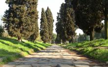
Appian Way in Rome is still evidence of the greatness of the Empire through whose territory it is laid. The history of the creation of the Appian Way dates back to the 4th-2nd centuries BC. It was built in stages:
- 200-kilometer stretch of road connecting Rome and Capua (IV century BC);
- 40 km – from Capua to Benevento (III century BC);
- 300 km - from Benevento to the port in the Adriatic Sea called Brundisi (2nd century BC).
The laying of the path began in 312 BC. by order of the consul and military leader Appius Claudius. The censor pursued not only ambitious goals. He created a canvas along which the rapid transition of troops to and from Rome was carried out. It also connected several regions of the Empire and was used as a trade route. These functions continued until the Middle Ages. Then the road began to be used by pilgrims visiting holy places.

Ancient construction technologies
The ancient masonry of the Appian Way is still preserved. The secret of its durability lies in the unique technologies of those times. The processed stones were laid on a flat surface covered with sand and pebbles. A border was laid on the sides of the canvas and recesses were dug for water drainage. The surface of the track is made slightly curved to prevent moisture retention. The width of the canvas is sufficient to move two chariots.
Some areas old Appian Way Lost coverage was not due to time. This is the result of people's actions. The owners of the plots of land located along the route used stones removed from the masonry to construct buildings.

Sights of the Appian Way
Before you know how to get to the Appian Way in Rome, it is worth familiarizing yourself with the list of attractions.
The journey can begin at the gate of San Sebastiano. This building attracts tourists with its varied architecture. Both parts of the gate have their own history:
- in the 3rd century BC a square lower tier was laid out of processed stone;
- in the 5th century the building was completed and strengthened. Semicircular towers made of brick appeared on a square base. They are decorated with crenellations and have small windows.
Everyone can visit the San Sebastiano Gate building, which has become a museum. For 3 € you can see an exhibition dedicated to the history of the development of fortifications. The price includes a walk along the walls, from the height of which you can see the ancient defensive structures. On Mondays the museum is closed to visitors.

Not far from the gate is the Domine Quo Vadis church. In its place there was a meeting between Peter and Jesus Christ.
Inside the temple there is a shrine - a copy of the slab with the imprints of the Savior's feet. The text engraved on the relic is a parting word for wanderers.
The next stage of the trip could be Carfarella Park. It occupies a vast territory, where it is customary to travel on foot or by bicycle. Two-wheelers can be rented here. Carfarella is interesting for its meadows, caves, and streams. Here you will not find modern food outlets: cafes and restaurants. On the way you will only come across small fountains with drinking water. You can visit a sheep farm and buy the cheese produced there.

If you don’t want to walk around the park, just turn off and go around it. In this case excursion along the Appian Way will continue in the burial places of the ancient Romans - Catacombe di San Callisto. You can visit the attraction on any day except Wednesday. Walking through the catacombs is allowed only in the presence of a guide. Ticket price 9 €.
Other famous objects are located along the canvas:

How to get to the Appian Way
There are two options for visiting the attraction: walking or traveling by vehicle. In the first case, the tourist will have to face some inconveniences:
- large expenditures of time and effort;
- lack of sidewalks;
- the need to constantly give way to cars.

How to get to the Appian Way in Rome? There are several solutions:
- Renting a car will cost 12-25 EUR per day.
- Travel by Archeobas tourist bus, which starts from Termini station.
- Travel by regular buses: number 118 goes from the Piramide metro station, and number 218 from the San Giovanni Cathedral.
Whatever method of transportation you choose, traveling along the Appian Way will bring only positive emotions!
Trish Hartmann / flickr.com Stefano Costantini / flickr.com Stefano Costantini / flickr.com Mitch Barrie / flickr.com Carole Raddato / flickr.com Larry / flickr.com Patrick Morgan / flickr.com Stefano Costantini / flickr.com Roger W / flickr.com faungg's photos / flickr.com Church of Domine Quo Vadis (Darold Massaro / flickr.com)
A very ancient statement, dating back to the Middle Ages, says: all roads lead to Rome. If we talk about Rome, these are truly true words.
After all, the location of its roads was planned in such a way that the Romans could easily reach any point of the Apennine, and its strong, closely packed stones could support more than one truck. Patrician of the Peninsula and more. And the Appian Way is clear proof of this.
The history of the Appian Way, well preserved to this day, began at the end of the 4th BC. e. It connected Rome with Southern Italy, and the port of Brindisi opened a sea route to such important countries as Greece, Asia Minor and North Africa.

Appian Way in Rome (Larry / flickr.com)
If we trace the direction of the road in more detail, then at the beginning of its operation it connected Capua and Benevente, and during half a century of construction the road could be reached to Brindisi. Here the Romans erected two impressively sized marble columns, marking the end of the Appian Way.
To this day, only one column remains at this place. However, the second column did not completely disappear from the face of the Earth. In the 17th century, it was presented as a gift to the city of Lecce, which survived a terrible plague. And to perpetuate the end of this deadly disease, a column with the figure of the patron saint of the city, Saint Orontes, was installed in the very center of the city. And now this structure is called the Plague Pillar.

Carole Raddato / flickr.com
The Roman censor Appius Claudius Caecus is considered the founder of this nationally important object. However, there are more ancient sources that already contain information about the road. It is known for sure that it was Appius Claudius Caecus in 312 BC. e. ordered to pave this road for the unimpeded movement of Roman legions and trade caravans from Rome and back.
The Appian Way played a fundamental role in achieving the military, trade and economic goals of Ancient Rome. The construction of the road was such an important event in Rome that its detailed description was found in the manuscripts of the historian Titus Livy.
According to the ancient Greek historian Diodorus Siculus, the construction of the road proceeded thoroughly; Appius approached his creation quite seriously. He ordered all the holes and ravines to be filled in, as well as the hills to be demolished in order to level the road surface as much as possible.
In order to increase its area and length without distorting the road, he ordered to get rid of all swampy areas. The construction of the Appian Way was not cheap, and cost the treasury a fairly large sum.
The Secret to Durability
The Appian Way is an ancient fundamental object of Rome, which has come down to us in an almost pristine appearance. It functioned until the 6th century. n. e., and even now its strong, closely packed stones can support more than one truck.
Patrician Appius Claudius understood the importance of the existence of this route and did everything in his power to successfully complete the construction of the Appian Way.

The Great Road of Ancient Rome (Stefano Costantini / flickr.com)
What is the secret of the durability of the Appian Way? It's all about the structure of the road surface, which has several layers of stones up to one meter thick. The top cladding consists of smooth and neatly fitted basalt slabs and cobblestones. Even after hundreds of years, their integrity was not destroyed by external disasters.
There is information that Appius Claudius, testing the quality of the road flooring, tried to insert the blade of a sharp dagger into the stone joints. If he was able to cut a gap, that section of road was immediately rebuilt and re-laid.
The road has an almost perfectly flat surface, which served as a good crossing for chariots and foot convoys.
The Appian Way has another unique feature - a central elevation, due to which water in any quantity did not linger on the road surface, and the road always remained clean and dry.
Appian Way and surrounding areas
The Appian Way is very well designed. Mileposts are installed at regular intervals along the sides of the road, indicating to their travelers the mileage of the route they have traveled. There are also rest areas and many other objects that are important for people who have traveled a considerable distance.

Cars driving along the Appian Way (Mitch Barrie / flickr.com)
The cities through which the Appian Way passed were equipped with churches, visiting courts and eateries. Some of its places are equipped with walking paths.
The width of the road, which is 4 meters, allowed two chariots to pass each other, and in our days - two cars.
During its existence, the Appian Way was both a warpath, a major trade and economic link, and a pilgrimage route. Now its already rich past has been supplemented with the status of a walking, tourist and sports route.
At the 1960 Olympic Games, it served as a platform for the marathon competition.
Tombs of the Appian Way
In Rome, legislation prohibited the burial of the dead within the city. For this purpose, areas of major roads extending beyond Rome were used, including the Appian Way. The section from Rome to Benevento was used more often for these purposes.
Even then, land for burial had a price: the closer the site to the city, the higher its value. Accordingly, the closer the burial was to the city limits, the more respected and rich the owner of the site was.
There are quite a lot of burials, the most prestigious and large-scale of them are:
- catacombs of st. Sebastian and St. Callista;
- the catacombs of the respected Scipio family, where the ashes of family members are kept in stone sarcophagi;
- columbarium of Pomponia Gila - a family which, judging by the rich decoration of the tomb, became rich after receiving freedom;
- The columbarium of the freedmen of Libya is striking in its size; it could accommodate several thousand urns.
Some burials look like temples and even entire pyramids. Six miles from the city, separate parts of funerary buildings, monuments and churches are kept, shrouded in greenery.
There were many violent events in the history of the Appian Way. After the pacification of the Spartacus uprising, pillars were erected along the side of the road, on which more than 6 thousand prisoners who took part in the revolt suffered a terrible death.
Church of Domine Quo Vadis - Where are you going, Lord?
In addition to the tombs, the Appian Way is famous for its country villas. The palaces of the Quintilii, the philosopher Seneca, Emperor Maxentius, and Clodius Pulcher attract attention.

Church of Domine Quo Vadis (Darold Massaro / flickr.com)
The main stopping point for most excursions is the Church of Domine Quo Vadis. From Old Slavonic the name of the church means: “Where are you going, Lord?”
The reason for the emergence of such a sacred name was the legend about the Apostle Peter: the apostle escaped from captivity and met Jesus Christ on the way, asking the above question, he heard in response: “To where I will be crucified again.” These words struck the apostle and he admitted his weakness. After some time, he returned to Rome, surrendered to the authorities and accepted martyrdom.
A special treasure of this holy place is a stone where footprints are clearly visible, which, according to some sources, belong to Jesus Christ.
Speaking about the sights of the Appian Way, it is necessary to remember the ruins of medieval fortresses and fortifications, the Circus of Maxentius, the columns of Hercules and Pius IX - these and dozens of other ancient structures form the “golden” row all the way from Rome to Brindisi.
Many buildings have not survived to this day. But even now the legacy of Rome unceremoniously speaks of the former greatness and power of the ancient Ancient state.
September 20, 2018
All roads lead to Rome - this expression can often be heard when talking about the Eternal City. One of the oldest is Appian Way, laid in the 4th century BC. Its length is almost 535 km (360 miles; 1 Roman mile corresponds to 1482 m), and it passes through several regions of Italy: Lazio, Campania, Apulia and Basilicata.
Appian Way: where it all began
In the first quarter of the 4th century BC, Rome was an important political and commercial center in Italy. During numerous military campaigns, the Romans conquered new territories and gained allies, strengthening their position in the Apennines and establishing trade, economic and political relations. The city grew and developed. One of the most large-scale construction projects of this period, as well as the most important military-strategic decision, was the construction of a new highway connecting Rome with the southern city of Capua. Construction of the road began in 312 BC. by order Appia Claudius Caecus, an influential statesman and military leader, and was subsequently named after him - Appian.
Historical reference
Appius Claudius Caecus (c. 350-273 BC) - ancient Roman politician, military leader, reformer. Considered the founder of legal proceedings. Thanks to Appius Claudius Caecus, the first aqueduct appeared in Rome and a strategically important highway was laid in the ancient world - the Appian Way.
One of the most ancient roads in Rome, due to constant wars, was built in several stages. The first section of the highway, connecting the capital of the republic with the city of Capua (province of Caserta, Campania), was built to solve military problems. Researchers suggest that the road itself existed here before, and Appius Caecus only gave it the proper appearance by paving it with stone.

A century later, the next section of the Appian Way was laid - from Capua to Benevento (province of Benvento, Campania), and by the beginning of the 2nd century BC. the highway reached Brundisia (modern Brindisi, Apulia). This contributed to the development of trade with eastern countries.
For many centuries, wealthy citizens built family crypts along the Appian Way. Some of them expanded over time, eventually turning into vast city cemeteries -. Numerous monuments and monumental tombs were erected along the road, some of which have survived to this day.
One of the main highways of the ancient world played its role until the 6th century, after which its trade and military significance gradually faded away. Appia Street was increasingly used by pilgrims traveling to Rome to venerate the relics and relics of saints buried in Christian catacombs on the side of the road.

In the Middle Ages, when most of the territory along the Appian Way belonged to the Holy See, many funeral monuments were dismantled and used as building material for the construction of new structures. In the 11th century, some land plots became the property of representatives of the nobility.
After the construction of the new Via Appia Nuova in the second half of the 17th century, the old one began to be called Appia Antica.
Appian Way: what to see
In ancient times in Rome it was forbidden to carry out executions and burials within the city. City cemeteries were located outside. Over the course of several centuries, family mausoleums were erected along the Appian Way, funerary monuments were erected, and public columbariums were established. Many of these structures can still be seen today:
- Porta Capena
- Mausoleum of the Scipios
- Arch of Drusus
- Tomb of Pomponius Gila
- Gate of San Sebastiano
- First mile column
- Tomb of Geta
- Mausoleum of Priscilla
- Church of Santa Maria in Palmis (Domine quo vadis)
- Freedmen's Columbarium
- Tomb of Volusia
- Catacombs of San Callisto
- Columbarium Vigna Randanini
- Column of Pius IX
- Catacombs and Temple of Saint Sebastian
- Crypt of Romulus and Circus of Maxentius
- Tower of Capo di Bove
- Crypt of the sons of Sextus Pompey
- Tomb of Ilarius Fusca
- Mausoleum of the Rabirievs
- Villa Quintiliev


After I left the walls of great Rome, With the rhetorician Heliodorus, the most learned man of the Greeks, Aricia soon sheltered us in a poor inn; Next was the Appian Forum, full of shipbuilders and rogue innkeepers. - We divided our move into two; but those who are not lazy and are in a hurry, even pass by during the day. We were in no hurry; Dear Appia, take it easy
.
The Appian Way (lat. Via Appia) is the most significant of the ancient public roads of Rome. The road was built in 312 BC. e. under the censor Appia Claudius Caecus, it went from Rome to Capua, and was later carried out to Brundisium. Through it, communication between Rome and Greece, Egypt and Asia Minor was established. 
Roman roads have survived to this day. The Romans built them thoroughly, to last for centuries. First, surveyors precisely mapped out the route of the road. Then a deep ditch of the required width was dug. It was filled with layers of stones. The upper part of the road was paved with huge, well-fitted cobblestones or stone slabs. To prevent the road from being washed away by rain, its middle was made higher than the sides, and ditches were dug along the road. The quality of construction of the Appian Way was such that even after 900 years it served perfectly without repair. And today, certain sections of the Appian Way have been preserved, striking in their inviolability. 
The Appian Way became the “ancestor” of the famous Roman roads, which were laid wherever Roman troops passed. Where the road approached the river, the Romans built bridges. Sometimes aqueducts - water pipelines - were built over bridges. Such bridges still exist in southern France, Spain and other places. Roman roads made it possible to quickly reach the remote outskirts of the state and develop trade. Many modern motorways in Europe follow roads laid out by the Romans.
Having conquered the tribes of central Italy, the Romans stubbornly advanced to the south of the Apennine Peninsula. They distributed part of the captured lands to Roman peasants. The Romans founded new cities and settlements where the inhabitants of Rome and Latium moved. During the Samnite Wars in 312, construction began on a road connecting Rome with Capua. This was done by order of the censor Appius Claudius the Blind, so the road was named Appian.
Along the Appian Way there are many monuments: tombs and villas from the Republican and Imperial periods, Christian and Jewish catacombs, medieval towers and fortifications, often built on the ruins of Roman monuments, Renaissance and Baroque buildings.
The Appian Way was built in three main phases:
IV century BC BC: The first section of the road, 195 km, was built from Rome to Capua for military purposes, to help the Romans against the Samnites. In “De aquaeductibus urbis Romae” (“On the aqueducts of the city of Rome”), the Roman statesman Sextus Julius Frontinus wrote that after 30 years of war with the Samnites, the censor Appius Claudius Crassus, who later received the nickname Caecus (Latin Caecus, “Blind”), ordered build a road from the Capena Gate to the city of Capua. However, perhaps the road existed earlier, before Appius Caecus, and the merit of the censor was that he gave it the right direction and paved it in the 3rd century BC. e.:
The second small section was laid from Capua to Beneventum (lat. Beneventum). In parallel to Benevento there was a Latin road, which may have been built even before Appia, Rome thus strengthened its position in Campania. Second half of the 2nd century BC. e.: Until 122 BC. The road from Beneventum was continued through Venusia and Tarentum to Brundisium. Thus, the Appian Way connected Rome with the Egnatian Way on the Balkan Peninsula and became the most important route for trade in goods and slaves from the East. 
In 71 BC, along the Appian Way from Capua to Rome, after the suppression of the Spartacus uprising, more than 6,000 captive slaves were crucified.  The Appian Way, fantastically transformed by the imagination of Piranesi
The Appian Way was of great military, cultural and commercial importance. Theodor Mommsen noted its importance as a military highway. Thus, the first section of the road was planned and built in 312 BC. e., that is, during the second Samnite war 326 to 304 BC. e. In the war against Pyrrhus and during the Macedonian Wars (206-168 BC), the Appian Way also served to support the Romans. Particularly important was the fact that during the construction of the road, Appius drew a canal through the Pontic marshes, which drained the land and simplified the departure of ships from Latium to Tarracina. Since antiquity, the road was of utmost importance, connecting Rome with such rich regions as Campania, Apulia and later for the development of trade with the East.
Already in ancient times, the Appian Way was called the “queen of roads” (lat. regina viarum): for example, the Roman poet Publius Papinius Statius (lat. Publius Papinius Statius) writes about this in the work “SILVAE” (“Forests”), book II: "Appia longarum teritur regina viarum"  Soon the Romans began to build monumental tombs and magnificent monuments along the road, the decoration of which became a matter of prestige. So, already 20 years after the opening of traffic along the Appian Way, representatives of the Roman family of Scipios built crypts for the burial of family members
The role of the road also remained in the Byzantine period, as a connection between Rome and New Rome, Constantinople. Under the emperors Diocletian, Maxentius, Constantine, Valentinian, some sections of the Appian Way were restored and updated
They were so tightly fitted to each other and seemed to be fused that to those looking at them they seemed not attached to each other, but fused together. And despite the fact that for such a long time many carts and all kinds of animals passed along it every day, their order and consistency were not violated, not one of the stones was damaged or became smaller, much less lost anything of its shine
Procopius of Caesarea. "War with the Goths"
Back in 536, the Byzantine historiographer Procopius, admiring its structure and ancient age, enthusiastically described the road. The Ostrogoth king Theodoric the Great ordered repair work on the road at the beginning of the 6th century and then used it to advance troops on Rome in 536.
During the Middle Ages, the road's importance as a trade and transport route began to decline, being used by pilgrims traveling to the catacombs, the Basilica of St. Sebastian, traveling further to the port of Brundisium, and then heading to the Holy Land. Many Christian saints and martyrs were buried in the catacombs on the Appian Way, for example, Saint Sebastian, Pope Callistus. Guidebooks have been preserved (lat. Epitome de locis sanctorum, 638-642) for pilgrims, which indicate the path to the shrines on the Appian Way. 
In the 9th-10th centuries, the Vatican owned large lands along the road, however, the monuments gradually fell into disrepair under the influence of weather conditions and human hands: building material was collected on the road - stone blocks, primarily travertine - for the construction of new buildings. In the 11th century, the church began to transfer possessions into the hands of the families of Roman barons and counts. Thus, the counts of Tusculan turned the tomb of Cecilia Metella into part of the fortress. In 1300, Boniface VIII Caetani gave this fortress to his family, whose representatives introduced high road taxes on goods and travelers, so that another route to Rome began to be used: through the New Appian Way (Italian: Appia Nuova) and the Porta San Giovanni 
At the end of the 16th century, Gregory XIII ordered the pavement of the Appia Nuova, thereby displacing the old Appian Way, which became an ordinary suburban road. At the end of the 17th century, Innocent XII built a road connecting the two Appian Ways: Appia Pignatelli. The remaining monuments continued to undergo further dismantling. Until the end of the 18th century, the Appian Way remained inaccessible. Interest in road excavations came with the "fashion" for hunting for the remains of saints and martyrs and supplying artifacts to museums and collections throughout Europe. In the 19th century, when it was cleared by order of Pope Pius VI, archaeologists carried out excavations on part of the Appian Way. 
Road route: Rome, Aricia, Tarracina (88 km.), Fundi, Formia (142 km.), Minturna, Sinuessa, Capua (195 km.), Beneventum, Venusia, Tarentum, Uria, Brundisium (540 km.)
Via Appia began at the Capena Gate (lat. Porta Capena) of the Servian Wall; it was from this place that the mile stones began to be counted. After the construction of the Aurelian Wall, part of the Appian Way was within the city limits. Further, the road passed to the Roman Gate of St. Sebastiano (lat. Porta San Sebastiano, formerly Porta Appia) of the Aurelian Wall, 90 km of a straight road to Tarracina, skirting Mount Albano from the south, crossing the Pontic marshes. The last 28 kilometers ran parallel to drainage channels, allowing an alternative route to be continued by boat, cart or horse
Emperor Trajan ordered the construction of a shorter road (Trajan's Way, Via Appia Traiana) from Beneventum to Brundisium via Barium, which reduced travel time to 13-14 days (travel along the Appian Way lasted up to 15 days). The Appian Way had branches that connected it with other major roads, such as via Domitiana (intersected at the city of Sinuessa, then went south to Naples), via Setina, which connected the Appian Way and the city of Setia (lat. Setia); Campanian road from Capua to Cumae (lat. Cumae); via Aquillia, which began in Capua in Salerna (Latin: Salernum); Via Minucia united Via Valeria and Via Aquillia and crossed the Appian Way and the Latin Way. 
Within the city limits of Rome, the road is today called the Old Appian Way (Italian: Via Appia Antica), to distinguish it from the New Appian Way (Italian: Via Appia Nuova), built in the 1780s between Rome and Lake Albano, and Via Appia Pignatelli lat. Via Appia Pignatelli, built around 1700 under Pope Innocent XII to connect the old and new Appian Ways. 
The costs of building and maintaining roads were enormous. Thus, the inscription on a tablet discovered on the Appian Way testifies to the work being carried out under the Emperor Hadrian: part of the costs was paid by the emperor, the other part by residents of adjacent villages. According to scientists, the cost per mile averaged about 109 thousand sesterces (for comparison: bread in 75 BC cost from two to three sesterces, and in the 1st century AD 600 sesterces for a slave was considered cheap)
The base of the road was paved with cut stones (from gray volcanic basalt - Italian selce, Latin silex), which were laid on a layer of pebbles and cement (see the main article Roman roads). The width (up to 4 meters) allowed two horse-drawn carriages to pass each other; on the sides of the road there were pavement-like elevations and deep ditches for draining rainwater.  One of the columns marking the end of the road to Brindisi
However, in one of his letters to his brother, Cicero reports that during floods the road near the Temple of Mars was flooded, and in another he warns of the danger of freezing “in the lowlands of the Appian Way.”
At a certain distance from each other there were road stations that served as resting places for travelers. One of them, the “Three Inns” (lat. Tres Tabernae), located 45 kilometers from Rome, is repeatedly mentioned by Cicero in letters and in his other works. The same station, called “Three Inns” in the synodal translation, is mentioned in the Acts of the Saints apostles (Acts 28:15).
Every Roman mile (1478 meters) there was a mile post (lat. colonna miliaria), indicating the distance and indicating the name of the emperor ruling at that time. The pillar of the first mile of the Appian Way has now been replaced with a copy; the remaining pillars have not survived. Every 10 miles there were rest areas. Two marble columns at Brundisium, erected in the 2nd century, marked the end of the road. Now in the port of the city there is only one of them (19 meters in height), decorated with images of Jupiter, Neptune, Mars and eight tritons; the second was moved in 1666 to the city of Lecce and was used as a plague pillar.
Monuments along the road
“Hominem mortuum in urbe ne sepelito neve urito” - “Let the dead not be buried or burned in the city.”
Table X, 450 BC. uh.
Roman law prohibited burials within the city, so the Romans used major roads leading from Rome for burials. Most of the monuments on the Appian Way were erected in the 2nd century after, instead of the Roman tradition of burning the bodies of the dead (previously, columbariums with urns appeared on the Appian Way), wealthy citizens began burying bodies in the ground. Thus, several kilometers of the Appian Way were used to build tombs and monuments (especially on the Rome-Benevente section), which gave the inhabitants of Rome the opportunity to show their wealth and position in society.
The price for plots of land at the beginning of public roads (Latin viae publicae), connecting the largest cities, was high, some were not intended for sale at all, therefore, the closer the burial was to the city gates, the more respected the owner of the plot was. The Senate tried to stop unnecessary decoration of burials, but the law could not resist the traditions of the Romans. The furnishings of the tombs included niches for urns with ashes (from the 2nd century, more often sarcophagi, stone benches and chairs, the walls were plastered and painted.)
Among the types of burials found on the Appian Way, the following stand out: Columbariums: on the Appian Way, columbariums of the Roman families of the Volusians, Caecilians, Carvilians, and Junius Silans were built; outside, above the main entrance, there was a marble plaque with the name of the person who owned the columbarium
Underground structures - hypogea and catacombs, underground burials with burial niches. The first tombs on the Appian Way were underground chambers carved into tuff, such as the Tomb of the Scipios. Later, extensive underground burials appeared, such as the catacombs of St. Sebastian and the catacombs of St. Callista; Small to medium-sized tombs, sometimes resembling a house or temple in shape; Monumental tombs are mausoleums built on the principle of Etruscan tumuli: the most famous is the tomb of Caecilia Metella.
Country villas of the Roman aristocracy were also built on the Appian Way, for example, the Villa Quintilii, the villa of Emperor Maxentius, the philosopher Seneca, Cicero's opponent Clodius Pulcher and other noble residents.
The section of the road located behind the Servian Wall began at the Capena Gate and, until the construction of the Aurelian Wall in the 3rd century, was outside the city limits
Capena Gate (lat. Porta Capena)- once the city gate of Rome, part of the Servian Wall. The Appian Way and the Latin Way began from this gate. They have not survived to this day. 
- small catacombs of the noble Scipio family, dating back to the 2nd century BC. e.; in the main room of the tomb there were stone sarcophagi of family members, in a more modest hall with niches for funeral urns - servants and freedmen;
Columbarium of Pomponius Hylas (lat. Pomponius Hylas) is a well-preserved chamber-tomb of the 1st century AD. e., found in 1831. Pomponius and his wife Pomponia Vitalina, judging by the rich decoration of the tomb, were wealthy imperial freedmen. Later, the tomb was expanded with niches for urns of the couple's descendants and relatives; 
- are part of the Aurelian Wall, from where the Appian Way began.

Marking the first mile from the Capena Gate The First Mile Column (Italian: Prima colonna miliaria) is a fragment of a column in the city wall one hundred meters from Porta Appia. The column marked the first mile from the Kapen Gate (1478 meters). The original column, found in 1584, is now part of the balustrade on the steps of the Capitoline Hill. Tomb of Geta (lat. Geta) is a tomb originally decorated with marble. At the moment there is no evidence that this was the burial place of Geta, the son of Emperor Septimius Severus; 
- the tomb was built for his wife Priscilla by Titus Flavius Abaskant, a freedman of the time of Emperor Domitian. The base of the tomb is quadrangular and was previously covered with travertine. It also contained a room in the shape of a Greek cross, in which there were sarcophagi and 13 niches. The entrance to the tomb was in the opposite direction and was closed by a farmhouse from the 12th century until recently. In the Middle Ages, an observation tower was built over the tomb from used bricks and marble fragments; 
Santa Maria in Palmis is a small church on the road. Two places on the Appian Way remind us of the escape of the Apostle Peter from the Mamertine prison: Peter tied his wounds with a bandage, but lost it on the road; at this place the chapel Ad Fascoliam was built, which was later rebuilt into the Church of Saints Nereus and Achileus (Italian: Santi Nereo et Achileo ). Beyond the Gate of Saint Sebastian, the apostle came to the place where the Via Ardeatina branches off from the Appian Way: he could go to the port of Ostia and then sail to Gaul, or continue along the Appian Way to Brindisi and then go to the East. However, at that moment Christ appeared to him, to whom Peter asked the question: “Where are you coming, Lord” (lat. Domine quo vadis?), to which he received the answer: “I am going to where I will be crucified again” (lat. Eo Romam iterum crucifigi). Peter returned to Rome and suffered martyrdom
- one of the largest Roman columbariums, which could accommodate about 3,000 urns. The columbarium was discovered in 1726 in a practically destroyed state, but sketches and a plan of the structure made by Piranesi were preserved. The building was a rectangle, in which there were four semicircular recesses and four square

From the 13th century, there is an underground pagan burial of the Vibia hypogea, which includes 8 separate hypogea on several levels. The catacombs, with their magnificent paintings, date back to the 3rd and early 5th centuries.
The most famous hypogeum, which gave its name to the catacombs, belongs to Vincent (lat. Vicentius), a priest of the cult of the Thracian god Sabathius, and his wife Vibia (lat. Vibia). The Hypogeum is decorated with paintings from the 4th century depicting the theft of Proserpina by Pluto, Jupiter Sabathius, Hermes Psychopompus (Guide of Souls);
Tomb of the freedmen of the Volusia family (lat. Volusia); The Catacombs of Saint Callistus are one of the largest Christian catacombs in Rome, used for burials during the 2nd-4th centuries;
Catacombs of Vigna Randanini (Italian: Vigna Randanini) - Jewish catacombs, burial places of the inhabitants of the Jewish community of Rome, who lived primarily in the Trastevere area and at the Capena Gate
Tomb of Volumnius (lat. Volumnius) 
Dedicated to the pope, who commissioned restoration work on the Appian Way in 1852. The work was led by the architect Luigi Canina (Italian: Luigi Canina), who considered the road and surrounding areas as a kind of archaeological park
Catacombs of St. Sebastian - this section of the road, due to the depression in the road, was called ad catacumbas, which later gave the name to all underground burials. Since the 11th century, the catacombs began to be called after St. Sebastian, as they are located under the Basilica of St. Sebastian (in honor of the early Christian martyr St. Sebastian; originally the Basilica of the Apostles - Memoria Apostolorum). The basilica acquired its modern appearance after restoration work carried out under Cardinal Scipione Borghese at the beginning of the 17th century; 
The emperor's son Maxentius, part of the monumental complex of the imperial palace and circus The emperor built a tomb for himself and his family at the beginning of the 4th century, but perhaps only his son Valerius Romulus, who died in 309 at the age of fifteen or sixteen years, was buried in it; Behind the tomb of Romulus on Via Appia Pignatelli is the Circus of Maxentius, built in 309; 
- monumental mausoleum of Caecilia Metella, daughter of the consul Quintus Caelius Metella Creticus, around 50 BC. e. The tomb was used for defensive purposes in the 11th century by the Counts of Tusculum and was converted into a fortress tower in 1299 by the Roman noble family of Caetani; 
III mile
The ruins of the once fortress of the Caetani family (lat. castrum Caetani) ;

Tower of Capo di Bove (Italian: Torre Capo di Bove)
- the ruins of a concrete tomb, shaped like a tower. The marble plaque mounted on the monument recalls the trigonometric measurements of the astronomer Father Angelo Secchi in 1855, which in 1871 served to verify the geodetic network in Italy; The Heroic Relief, a funerary stele with a marble relief, the original of which is kept in the National Roman Museum, was part of an unsurvived monument from the Republican period. The relief depicts a naked young man in a heroic pose with a cape on his shoulders and a Hellenistic weapon at his feet;
Tomb of Marcus Servilius (lat. Marcus Servilius)
-with relief fragments in the wall. The monument was the first monument on the Appian Way to be restored in 1808, with Antonio Canova attempting to “preserve” the reliefs at the site of their discovery rather than transfer them from the tomb to museums.
IV mile
"Tomb of Seneca" in the form of a column of simple brickwork, completely devoid of decorative fragments. Monument known as the tomb of Seneca, in memory of the philosopher and tutor of Nero, owner of the villa on the IV mile of the Appian Way. Quadrangular base of a round mausoleum from the times of the early republic with fragments of a frieze in the wall; in the burial chamber there are two sarcophagi;

Tomb of the sons of Sextus Pompey (lat. Sextus Pompeus Iustus)
- decorated with poetry - a brick structure with a triangular tympanum built by Antonio Canova. The tympanum is decorated with a verse written in hexameter, in which Sextus Pompey recalls the premature death of his children. Numerous decorative fragments were inlaid into the walls of the tomb. Only one fragment of the sarcophagus has survived, depicting a married couple;

Tomb of Saint Urban
-Bishop of Rome, successor of Saint Callistus. The monument, built of brick on a high pedestal, dates back to the 4th century. In the Middle Ages, the Borgiani Tower was located above the base of the tomb. At the end of the 19th century, near the tomb, the ruins of the villa of Marmenia (lat. villa Marmenia), a Roman noble woman who converted to Christianity, were found. Fragments of the villa date from the Republican period, partly from the 4th-5th centuries. A tomb “with a Doric frieze” made of tuff in the form of an altar, decorated with a frieze with images of a helmet, vases and rosettes. The tomb, dating from the Republican period, was rebuilt by Canina and has recently been restored by the Archeology Authority of Rome;
Tomb of Hilarius Fuscus
- a triangular pediment built by Canina - a print of a funerary stela, which is kept in the National Roman Museum. The pediment bears five portraits: in the central niche there are images of a married couple, possibly with their daughter; two male figures are presented in two side niches. Based on the image of hair decorations, it was possible to establish the date of construction of the tomb - around 30 BC. e. The rectangular brick columbarium dates from the mid-2nd century, with niches for urns located at various levels; The Brick Columbarium is another rectangular shaped columbarium;
The Tomb of the Freedmen of Claudius is the burial place of a family freed under Emperor Claudius: the head of the family Claudius Secundinus (lat. Claudius Secundinus), a copyist, messenger, and his wife Flavia Irene (lat. Flavia Irene) and their two children; The tomb, reminiscent of a temple in shape, is made of brick and richly decorated with relief friezes;
 Tomb of the Rabirii (lat. Rabirii)
- the tomb, shaped like an altar, was rebuilt by Kanina, who collected marble fragments found near the burial. The relief depicts Gaius Rabirius Hermodorus, his wife Rabiria Demaris, possibly freedmen of C. Rabirius Postumus, a merchant and banker.
V mile
 Pyramid tomb

Tomb of the Curiati

Villa Quintiliev Casal Rotondo
Tomb - tumulus Curiacii (lat. Curiacii);

Tomb - pyramid ;
Villa Quintilii
- ruins, popularly called “Old Rome” (Italian: Roma vecchia) The brothers Maximus and Condin (Latin: Maximus, Condinus) of Quintilia were persecuted under the emperor Commodus and were killed. Their villa was confiscated and was constantly expanded and rebuilt until the 4th century. The villa's nymphaeum (nymphaeum is a temple in the form of a grotto with a fountain, dedicated to nymphs), a hippodrome and a water reservoir overlook the Appian Way. The Nymphaeum was rebuilt into a fortress in the 5th century. Statues from the Villa Quintilii are kept in the Vatican Museums;
Ruins of the tomb of the Supsifanii (Italian: Supsifanii). The inscriptions indicate that the tomb was built at a cost of 27 thousand sesterces;
Tomb of Septimia Galla (lat. Septimia Galla);
Stone of Publius Sergius Demetrius (lat. Publius Sergius Demtrius) - winemaker from Velabro; Casal Rotondo is a cylindrical tomb from the times of the Republic. Later it was expanded and restored. Now on its foundation there is a peasant house with a garden and olive trees.
VI mile
On this stretch of road, many individual fragments lie in the grass.
Basalt Tower (Italian: Torre Selce) is a pyramid-shaped burial site built in the 12th century from basalt fragments;
Red Tower (Italian: Torra Rossa) made of reddish tuff;
Tombstone of Marcus Pompey (lat. Marcus Pompeius) ;
Doric columns, columns of Hercules - possibly the ruins of the Temple of Hercules of the Emperor Domitian;
Tomb of Quintus Cassius, marble merchant; Brick tomb of Quintus Verannius, Nero's legate in Britain; The Torraccio di Palombaro is a tower-like structure with four apses that was rebuilt as the Church of Santa Maria Madre di Dio in the 10th century and is therefore well preserved.
From mile VI to Brindisi
About 16.5 km from the Kapensky Gate, at the end of the ninth mile, there was the first postal station where horses' armor was changed. Mutatio ad nonum. The territory of the city of Rome ends 300 meters from this place. Beyond the Rome-Terracina railway crossing, the old Appian Way connects with the new one at the town of Frattocchie (Italian: Frattocchie). In modern Terracina are the ruins of the Temple of Jupiter Anxur
(lat. Jupiter Anxur, Anxur - that’s what the Volscians called this settlement), dating back to the 1st century BC. e. Here Emperor Trajan ordered part of the rock to be demolished to reduce travel time. The tomb of Cicero is located in Formia.
The idea of a large archaeological park in the area between Trajan's Column and the Castelli Romani arose during the Napoleonic Wars. Restoration work on the road began by Pope Pius VII at the end of the 18th century, and was completed by Pope Pius IX in 1852. Leading archaeologists, scientists, engineers, and artists took part in them. For example, the burials at mile IV were rebuilt by Antonio Canova, and from mile IV to the town of Frattocchie - by Luigi Canina. In 1931, Via Appia Antica was included in the city plan as a "major park".
After the Second World War, plans arose to develop the road with residential buildings, as well as a project for a luxury residential area on the site of the Quintiliev Villa.
The Roman ring road (Italian: Grande Raccordo Anulare) crossed the old Appian Way at the seventh mile, but the damage caused was only recently repaired.
In 1955, Pope Pius XII dedicated the first stone of the Olympic Stadium, which was to be built over the catacombs of St. Callistus, but the project was stopped due to public outcry. Along with major projects on the road, private unauthorized projects were constantly being implemented, houses were being built, land and buildings were being grabbed to create uncontrolled industrial activities. A small group of architects, urban planners and journalists opposed the government's efforts to develop the Appian Way. In late 1960, the state limited the park area to a few meters on each side of the road. In 1979, Mayor Argan considered a proposal to create an extensive archaeological park in the center of Rome, and it was not until 1988 that the establishment of a regional park via Appia Antica was approved.
Burial in the catacombs
The entire area of the Appian Way Regional Park has been closed to traffic on weekends and holidays since March 1997. Today, the Appian Way is a state road - Italian. Strada Statale 7 Via Appia, partially paved, but large sections of the road with an antique surface have been preserved, in places with deep ruts, knocked out by the wheels of carts and chariots.
In the 20th and 21st centuries, the Appian Way has become a popular venue for various sports competitions. During the 1960 Olympic Games in Rome, marathon competitions were held here
In painting
Engravings of the “Appian Way” from Piranesi’s “Roman Antiquities” (1753).
"Goethe in Campania"
is a famous painting by the German artist Johann Heinrich Wilhelm Tischbein, in the background of which are the Albano mountains, the ruins of aqueducts and the tomb of Caecilia Metella. Tischbein wrote in one of his letters that he depicted the writer sitting on the ruins and pondering the fate of human creations
“Appian Way at Sunset” - painting by Alexander Ivanov, 1845, State Tretyakov Gallery
%2C_Via_Appia%2C_1867._Oil_on_canvas%2C_Georgia_Museum_of_Art%2C_University_of_Georgia.jpg/800px-John_Linton_Chapman_(1839%E2%80%931905)%2C_Via_Appia%2C_1867._Oil_on_canvas%2C_Georgia_Museum_of_Art%2C_University_of_Georgia.jpg)
American artist John Linton Chapman (1839-1905) painted views of ruins on the Appian Way in 1869 (a total of 10 paintings dedicated to the road
In literature
Horace in his Satires describes his journey from Rome to Brundisium along the Appian Way. Byron “Childe Harold”, verse IV is dedicated to Rome and its attractions, for example, Byron’s hero ponders at the mausoleum of Cecilia Metella who this Roman woman could be.
In A Journey to Italy (German: Italienische Reise), Goethe describes visiting the ruined tombs of the Appian Way, including the mausoleum of Caecilia Metella. The writer noted that “when you see it, you only begin to understand what strong masonry means. These people worked for eternity, everything was taken into account by them, except for reckless, wild barbarism, from which there is no salvation."
Charles Dickens in Pictures from Italy described a journey along the Appian Way.
Once on the Appian Way, you can drive for a long time past collapsed tombs and collapsed walls, only here and there coming across an abandoned, uninhabited house; past the Circus of Romulus, where the chariot track, the place for judges, competitors and spectators, is perfectly preserved; past the tomb of Caecilia Metella; past barriers of every kind, walls and posts, fences and wattle fences, until they came out onto the open plain of the Campania, where on this side of Rome there is nothing but ruins. Apart from the distant Apennines rising on the horizon to the left, the entire vast space before you is complete ruins. Destroyed aqueducts, from which only the most picturesque rows of arches remain; destroyed temples; destroyed tombs. A whole desert of ruins, inexpressibly sad and gloomy, where every stone bears traces of the history of Charles Dickens. "Pictures of Italy"
Sources :
1. Titus Livy History of Rome from the foundation of the city (book IX) (rus). 2000.. Website of the Appian Way park (Italian).
2. Sergeenko, M. E. Life of Ancient Rome. ed. prof. S.L. Utchenko "Anthology on the history of ancient Rome". Gegenwart. - Munich: Artemis, 1990.
3. Goethe, I.V. "Journey to Italy".
Appian Way in Rome (Italy) - description, history, location. Exact address, phone number, website. Tourist reviews, photos and videos.
- Last minute tours to Italy
The Appian Way is, if translated into modern language, the first ancient pedestrian and horse-drawn highway. At one time it connected Rome with the far part of the Apennine Peninsula, and today it is a generally recognized landmark of Italy.
Peculiarities
The quality of this road was amazing for its time, and even one of the ancient Roman writers noted its solidity, the fit of one cobblestone to another. Some time later, the Romans began to place their richly decorated tombs along this “queen of roads,” which was considered prestigious.
It was used by the Romans for trade and military campaigns, and later by Christians - for pilgrimage to the holy places of Rome, but in the 19th century. the road fell into final decay and oblivion befell it. Interestingly, at the 7th kilometer it was crossed by a modern highway, so this section of the road suffered serious damage.
Modernity
Today, a regional park is located on one of the sections of the road, and the road itself has state status. Excursions along this route will help you learn more about its history and many of both modern and ancient buildings.
Today, the Appian Way is a state road (Strada Statale 7 Via Appia), partially paved, but sections of the road with an ancient surface, in some places with ruts, knocked out by the wheels of carts and chariots, have been preserved. The entire territory of the Appian Way Regional Park is closed to traffic on weekends and holidays.
Notable places and museums
Museum at the Gate of St. Sebastiano (via di Porta San Sebastiano) is the largest and best preserved city gate of ancient Rome, which is also part of the Aurelian Wall.
The Catacombs of St. Callistus (Via Appia Antica, 110) are one of the largest Christian catacombs in Rome, the burials in which date back to the 2nd-4th centuries. They contain many frescoes and inscriptions that testify to the life and death of members of the Christian community of Rome in the first centuries of the new era. The cost of visiting is 8 EUR, children 5 EUR. Opening hours: 9:00-12:00 and 14:00-17:00.
Appian Way
Basilica of Saint Sebastian and catacombs (via Appia Antica, 132-136). Opening hours: Monday to Saturday, 10:00-17:00. Closed on Sunday. How to get there: from San Giovanni metro station by bus 218. Visiting is only possible with a guided tour; a full ticket costs 8 EUR, a child ticket costs 5 EUR.
Circus of Maxentius, Mausoleum of Romulus (Via Appia Antica, 153).
The tomb of Caecilia Metella and the Caetani fortress (via Appia Antica, 161) is a monumental round-shaped structure that was erected around 50 BC. e. for Caecilia Metella, daughter of the consul Quintus Caelius Metella Creticus.
Villa Quintiliev and aqueduct (via Appia Nuova, 1092).
Hypogeum of Vibia (via Appia Antica, 103).
Jewish catacombs of Vigna Randanini (Via Appia Pignatelli, 4) and other attractions.
Prices on the page are for April 2019.


Human papillomavirus infection (Human papillomavirus)
Anastasia the pattern maker prayer for liberation Anastasia the pattern maker's prayer for liberation
Conspiracy against worms Is there a conspiracy or prayer for worms
What is same-sex marriage and why is it being legalized in Russia?
Hero cities of the Great Patriotic War